As a Vietnamese, from the crew of the road to the people who are not passionate about travel, everyone has a desire once to be set to 4 Pole 1 vertex? Across the country map, 5 places not only have beautiful natural scenery, unique local cuisine, but also a place to mark the territory of the country's sovereignty.
[caption id = "attachment_2422" align = "aligncenter" width="600 0"] 4 Pole 1 peaks-attracting tourism lovers to explore. North Pole:
The Valley of the
South Pole: The
westernmost Maui:
A easternmost Pa:
The tip of Fansipan 3 [/caption]
1. The North Pole – The national flag of the Valley of the Owl.
Ha Giang has long been a fascinating destination attracting tourist lovers. Ha Giang Beautiful every season of the year, tourists love ha Giang by the pass-not-so-to-come, rock cliffs that overlap the scallop, see the yellow-rice ladder-wheat rice fields or the triangulum… [caption id = "" align = "aligncenter" width = "600"] Ha Giang Rice season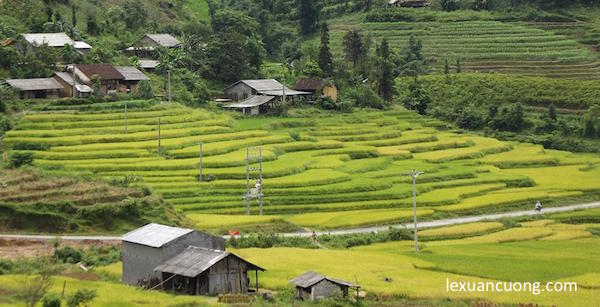 nine [/caption] and more specifically when coming to land ha Giang, no one can skip the Owl Valley, where it is seen as the northernmost point of the country, where we are only mentioned in the book (reality On the map, the northernmost point is located on the Cinnamon grape line-to go to the need for permission and guidance from the Valley border guards. [caption id = "attachment_2407" align = "aligncenter" width = "
 400"] The Owl-ha Giang banner, seen as the northernmost landmark in Vietnam. [/caption] The OWL flag was built on the top of the mountain at about 1470m in 2010. The flag column has a total height of about 33.15 m and the flag has an area of 54m2 which symbolizes 54 people, always tossing and towering the outline. Climbing to the ring of the Owl Valley, it also takes a lot of time to climb three levels, but when standing under the flag of the country, gaze at the country's sperm, watching the rice fields that are ripe in gold will make how much difficult to vanish , there is only more sense of love to the country and the land. [caption id = "attachment_1456" align = "aligncenter" width =
 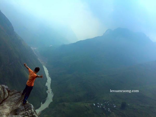 "600"] The grape cinnamon runs along the code pass Pí on Ha Giang Street [/caption] to go to the OWL-flag column, from Ha Giang city, people will usually choose motorcycles, run under Highway 4c Road, upstream to the northern River. And during a visit to Ha Giang, the Owl Valley, also forget to stop looking at the double mount, the masterpiece of nature-the place brings in his story of the love of the people of the Mongolian and the beautiful fairy. Resting in the Pine Hill, the Pine Hill extends tens of kilometers, translucent in the dew early, around poor roads, making people think of the second Dalat. Walk through the path of "happiness"-the scenic, the four peaks of the northern pass-the most dangerous and the most difficult. Also don't forget to go to the old town, make a win or a triangle pie, cakes only in Ha Giang, which cannot be found elsewhere. [caption id = "" align = "aligncenter" width = "
 600"] Double Mount-Ha Giang [/caption]
2. On the West visit the southernmost point: Cape Cà Mau
MUI Ca Mau is located in Ca Mau City more than 100km south, after reaching the city of Cà Mau by airplane or passenger, you will have to take one more time to go about five grounds to continue to move by waterway to land resort The nose, which is seen as the southernmost point of the country, and is built two symbols that attract tourists, who also want to be placed in the national coordinates of the country (GPS 0001) and the Mau tip of the surf ship to the sea. [caption id = "attachment_2413" align = "aligncenter" width = "600"] The country's coordinates, seen as the southernmost point in Cà Mau, Vietnam. [/caption] Currently, there were roads that could use motorcycles to go straight out extreme points, but before, you'd have to buy Cano tickets or to rent a small (western type in the West), and move over the river more than 2 hours to the extreme point. Sunny summer weather fires people, but the novelty of the mangrove forest always has the elusive lure. Special will be extremely interesting if anyone ever watched the "Land of the South", do not forget to watch the observatory for panoramic views over the country's south. [Embed] https://www.youtube.com/watch? v = JvqhRGZyC_k [/embed] The thousands of mangroves and the vast river of water, put your feet here, you'll probably add happiness and pride. And also do not forget to enjoy delicious food, Western essence to a memorable trip.
3. Westernmost a Pa comb, a three-country triple listener
If there are four easternmost points northwest of North West, the place for most people is perhaps the westernmost A Pa comb, located in the tender commune, Huyện District, Muong Nhé. [caption id = "attachment_1023" align = "aligncenter" width="6000"] the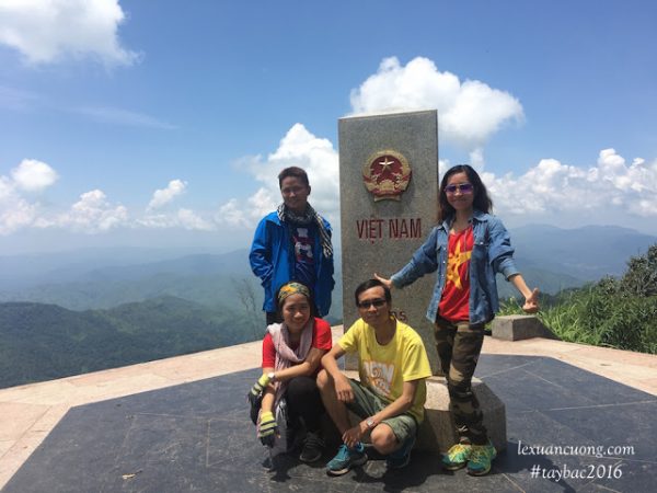 westernmost point A Pa brushed at the boundary, the three border falls. [/caption] A Pa Comb is also the place to set the border junction of the three borders, where "a three-country stethoction," marked the border of the three countries of Vietnam, Laos and China — and also the westernmost point on the mainland of Vietnam. The zero milestone is constructed of approximately 2 meters in height, with three sides each with the country's name and coat of arms. [caption id = "attachment_2424" align = "aligncenter" width = "600"
 ] Granite milestones on the junction of A panel of brushes [/caption] [caption id = "attachment_2420" align = "aligncenter" width="6000"] the t
 rekking road to the top of Mt A Pa brushed is quite steep and drowning. [/caption] The way A Pa comb is filled with difficulties, challenges for both experienced people. But make sure the generic way to A comb Pa will always be as beautiful as covering other Northwest roads. I came to A Pa comb in the 2016 rainy season, when the northwest was in the rainy season and had many serious landslide points. From Sa Pa, it takes two days of motorbike runs, through Muong Tè, and… beyond knowing how many passes and points of the Avalanche, the new to be rumored to be a PA comb, where management and licensing of the landmark No. 0 A pa comb. [caption id = "attachment_1022" align = "aligncenter" width = "60
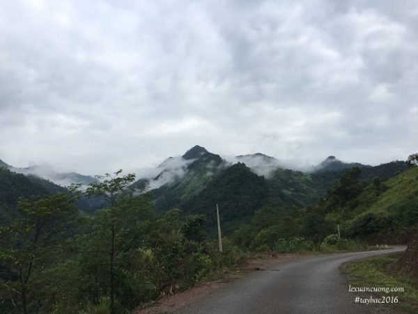 0"] The line-up-Muong Lay Palace in the clouds [/caption] Now the path to visiting landmarks is under construction of the page, however, after the end of the motorbike, you must continue to follow the trail up to 1864m high-drilling mountain compared to sea level , where the landmark is located with about 2 hours away continuously. And when set foot up the extreme West Point, you certainly won't regret the time and effort yourself off for this trip. The westernmost point is probably the hardest point in 4 extreme points. Conquering the West pole, you will want to go back to northwestern more again, to see the rest of the villages in the early dew, the poor roads overturn the mountain, the babies with the two…
4. The easternmost spot the dawn on mainland Vietnam
From the time being known, the controversy is that the South Pole is the southern point between two power (Phu Yen), and the double nose (Khanh Hoa) is still in the vibrant place. Even if the point is Far East, then the two destinations are sure to be attractive and full of attraction to everyone. The nose is also known as the head of the Atlantic in the Dong Hoa district, Phu Yen Province. Current nose travel has been invested in management, ticket collection, construction of the observatory, Vacation scaffold… Today, you can combine your visits to landmarks, a great lighthouse or beach bath. [caption id = "attachment_2415" align = "aligncenter" width = "600"] The nose, the point of Phu yen, is the easternmost of the mainland of Vietnam. [/caption] The post-territorial lighthouse was constructed by the French at the end of the 19th century, having an important effect on maritime transport, and one of Vietnam's most popular lighthouse. The lamp from the Great lighthouse as well as other lighthouses, will incorporate a guided effect, locate the boats when moving at night. [caption id = "attachment_2410" align = "aligncenter" width = "600"
 ] Lighthouse of the Cape, one of the most beautiful lighthouse in Vietnam. [/caption] The Light house has a circular cylindrical design, white paint, 26.5 m elevation and is located atop the mountain at about 110m above sea level. Inside lighthouse is a beautiful wooden spiral staircase. To lighthouse, remember to climb to the top of the lighthouse to see a panoramic view of the beach and the landmark "The first full dawn on the mainland of Vietnam". After visiting the lighthouse and landmarks, do not forget to bathe the beach, one of the most beautiful clean beaches… it has a golden sands, a magical blue water and streams that flow from inland to the sea. Double nose-the head, which is more favorite by the people, is under the measurements of coordinates and Google Maps, which are on the east coast with little power. Besides, getting to the double nose, long is also considered a challenging and challenging journey. [caption id = "attachment_2418" align = "aligncenter" width = "600
 "] Double nose-The easternmost point of the mainland of Vietnam. [/caption] To simple, you can hire the train to come out, but most of the young friends select the trekking, supply the trekking lines with various terrain and scenery. From the dam, we must overcome the high sand hills, about 12km of trans-jungle trekking, and the new rapids can reach the easternmost inox, which is not too long enough to be the most powerful. [caption id = "attachment_2416" align = "aligncenter" width = "600
 "] Cross the Sand Hill, ordeal on the easternmost trekking supply. [/caption] [caption id = "attachment_2417" align = "aligncenter" width = "
 600"] Trekking the extreme east, the memorable journey. [/caption] The spectacular sea, challenging rock rapids, with a sense of desire to touch the stainless steel, to the easternmost point of the country will surely help you to dispel everything tired of the way past.
- Reference: Guide Trekking Double nose-the easternmost point on the mainland of Vietnam.
5. Fansipan Peak 3143m-The roof of Indochina:
With a height of 3.143 m above sea level, Fansipan is the tallest mountain peak in Lao Cai province. Touching the Inox mold, standing on the ecliptic, watching the pristine forest… is the Convention of not only the Vietnamese Earths. [caption id = "attachment_2408" align = "aligncenter" width = "600" ] Conquest of Fansipan Peak in 2013 in cold 10 degrees C. [/caption] Supply Trekking Road, the shortest mountaineering trekking is the top-notch Fansipan-ton station at a length of about 24 km, you can take in 1-2 days of walking and climbing the cliff continuously. With trekking lovers, the Fansipan Palace is not too difficult, but also a beautiful road, you just have to travel along the streams, just see the maple leaves, the flowers are rich in color… The feeling of waking up early, on top of the mountain watching sunset, sun after the white cloud is sure it will be difficult to forget. [caption id = "attachment_2409" align = "aligncenter" width = "6
 00"] The conqueror of Fansipan crosses many streams, high slopes… and beautifully pristine forests. [/caption] Currently, there is a cable that hangs at the top of Fansipan, but still a lot of young friends choosing the trekking, going by his feet, touching the mountain of many meanings.
- Reference: Top 10 highest peaks in Vietnam